
ON THE AGENDA: Twentynine Palms City Council, March 25, 2025
Should Base adjacent General Commercial zoning become Service Commercial? How to better manage street vendors? Who should sign agreements on EIR reimbursements? Plus cracked roads slated for repair.

Community Development Director Keith Gardner is at bat for the Tuesday, March 25, 2025, Twentynine Palms City Council meeting. Items addressing Environmental Impact Reports, street vendors and zoning emanating from the Planning and Code Enforcement departments are the sole discussion and action items scheduled. The agenda is available on the City’s website.
The meeting kicks off with two closed sessions beginning at 5:15pm, one of which is the continuation of the nearly 1-3/4 hour session1 for the performance evaluation of the City Manager from the March 11 meeting. The public meeting is scheduled to begin at 6 pm. The Mayor should report the results of both closed sessions after an invocation by Pastor LeeAnn Clarke of 29 Palms Ministerial Association.
CLOSED SESSION PURSUANT TO GOVERNMENT CODE SECTION §54957 - PUBLIC EMPLOYEES PERFORMANCE EVALUATION, CITY MANAGER.
CLOSED SESSION PURSUANT TO GOVERNMENT CODE SECTION §54956.9 ANTICIPATED LITIGATION (1 CASE).
PUBLIC COMMENT
You can comment on agenda items and issues important to you at every City Council meeting. Comments on agenda items take place during discussion of that item, while comments on non-agenda items take place near the end of the meeting. The Brown Act prevents Council from commenting on non-agenda items. To comment, just pick up a green or gold form at the entry desk, fill it out, and hand it to the Clerk, who usually sits just in front of the Council bench toward the right.
Here's the list of Council email addresses to write if you can't get to the meeting — be sure to email them prior to 2 pm on the date of the meeting so they have time to read your email prior to discussion. You can also copy the clerk at cvillescas@29palms.org and ask that your letter be made part of the public record.
AWARDS, PRESENTATIONS, APPOINTMENTS, AND PROCLAMATIONS
This item ran for 45 minutes at the prior meeting, so residents, staff and Council alike are probably delighted to see a rare “none” here.
CONSENT CALENDAR
The Consent Calendar consists of routine items usually approved with a single vote. The public is given a chance to make public comment on these items prior to the Council motion. Again, fill out a comment form if you wish to address any of the items on this meeting’s Consent Calendar. Often the Council Consent Calendar lists a dozen or more things but this meeting's is slim indeed, containing just a single substantive item.
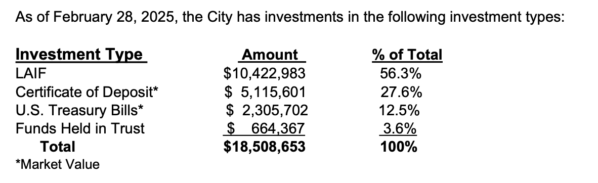
In addition to usual items such as approval of the March 11 meeting’s minutes, the warrant register covering expenses of $1,790,045.92 from February 5 to March 12, 2025, and an annual review of City investments, which remain unchanged, are two further items:
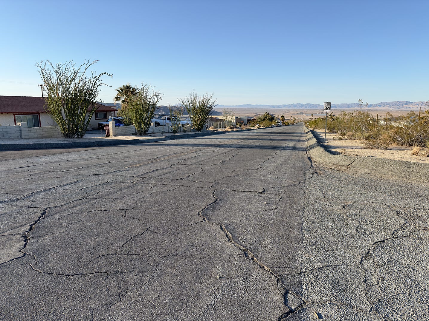
7. Material Acquisition for Road Overlay from Blue Diamond Materials.
This item allocates $212,000 in funding from Measure I, a half-cent San Bernardino sales tax, to address issues raised by residents on three City roads:
Old Dale Rd. from Manzanita Ave. to El Sol Ave.
Joshua Dr. from Lupine Ave. to Morongo Rd.
Indian Cove Rd. from Sullivan Rd. to Hwy 62
8. Lease agreement with Family Service Association of Western Riverside County.
Per the staff report, the City has an on-going month-to month-lease agreement that currently charges the Family Service Association of Western Riverside County2 $485.10 per month to use the kitchen and dining areas of the 29 Palms Senior Center to conduct a Nutrition for Seniors program. The program is supervised by the City and Reach Out Morongo Basin, the nonprofit that manages the Senior Center.
The current lease was initiated in 2005 and rental fee was meant to increase by 5% each year. However, the increase has only been applied twice in 20 years — this item proposes to update the lease for that yearly percentage resulting in the annual rent going from $5,821.20 to $14,004 as of March 1, 2025. The staff report doesn’t mention how much notice, if any, the Family Service Association has been given for the increase. Additionally the new agreement outlines safety measures that apparently were not included in the prior agreement such as proper storage and cleaning of food equipment, food handling certifications, mitigating tripping hazards as well as maintaining insurance — although the requirements were missing from the agreement in the report.
PUBLIC HEARING
There's no public hearing at this meeting.
DISCUSSION AND POTENTIAL ACTION ITEMS
9. North Adobe Commercial Area

Planning is requesting Council direction on whether the City should study rezoning several parcels located mostly northeast of the intersection of Adobe and Val Vista roads from their current status as General Commercial (CG) to Service Commercial (CS). This area is adjacent to and immediately south of Adobe Flats military housing on the Marine Base and a short distance from Condor Elementary School, also on the Base.
Per the City’s Development Code, these are the definitions:
General Commercial (CG). The CG land use serves as the City's primary commercial designation, allowing a broad range of commercial, retail, professional office and service-oriented businesses, including supermarkets, restaurants, hotels/motels and specialty retail stores.
Service Commercial (CS). The intent of the Service Commercial District is to allow for heavier commercial uses and light manufacturing uses. The CS land use allows for more intensive commercial uses, such as wholesaling operations, auto and truck repair and service, lumberyards, machine shops, light manufacturing and recycling centers. The areas in this district shall be completely separated or shielded from other incompatible land uses. High-quality design standards are encouraged to mitigate aesthetic impacts.
The code section also includes a chart outlining specific use cases and whether they’d be ministerial or subject to a Site Plan Review (SPR), Administrative Use Permit (AUP) or Conditional Use Permit (CUP).
Whenever Desert Trumpet views an item such as this one, the first question we ask is, who benefits? Why is this rezoning potentially being considered separately from the “General Plan Update” already on the Future Agenda Items list, or is it related to this item?
We researched the parcels using the map provided in the staff report as a guide. The colors on the map align with the Land Use Map from the 2012 General Plan: red is CG; green is Park and gold is Multiple Residential. Note that parcel boundaries on the map provided by staff do not always align with boundaries on the City Community Map or the County Parcel lookup system.
Also while the staff report states that the parcels are zoned CG, in fact they are a mix of CG and Single Family Residential (SFR). Most of the parcels are vacant but 7, 11, and 25 appear to have structures on them — it’s likely the SFR designations and parcels predate the 2012 General Plan. Rezoning the SFR parcels could trigger a SB 330 offset, which would require the City to increase residential density elsewhere to compensate for the lost SFR land should this item move forward.
Per our calculations, GO Family Trust owns the largest panel, #36 on our map, which is 120 acres zoned SFR. They also own three small adjacent SFR parcels (#18, 20, 22).
29 Palms Developers owns the largest CG parcel (#2, 17, 19 at 66.77 acres), an additional CG 6 acres (#6) and two SFR parcels totaling 10.7 acres (#3, 7). An associated LLC with shared principals, Salton Sea Estates III , owns an adjacent 3.84 CG parcel (#21) and two SFR parcels (#8, 32) totaling 6.57 acres. The principals of 29 Palms Developers LLC are Dennis C. Rieger, Greg Bolinger, John Malone.
Several of the parcels are landlocked and without street access, including a 5-acre SFR parcel owned by Planning Commissioner Jim Krushat (#10).
Two 20 acre parcels abut the eastern border of the Base residential area. Those are owned by Hutskin Investments (#34, CG) and the Pinksy Family Revocable Trust (#35, SFR).
The rest of the parcels vary in scale from 10 to .16 acres and are owned by a usual mix of LLCs, Family Trusts, construction and other businesses and individuals. A list of the larger parcels is footnoted below.3
Per the staff report, “More than one property owner within this area has approached Community Development Staff about potentially constructing such items as self-storage facilities, auto repair, and other light industrial uses.” It’s unknown whether they include the three apparent residences or those living in the adjacent Base housing. Perhaps we’ll find out who seeks to benefit in public comment?
10. Environmental Impact Report Agreements
It is common for cities in California to require that development project applicants bear the expenses of Environmental Impact Reports (EIRs), including expenses incurred by the municipalities where the potential development is taking place. Los Angeles, for example, requires a $15,000 deposit toward the cost of these reports.4 EIRs are comprehensive studies of the effects developments have on the region being altered and may include evaluations for traffic, air, water, biological, archeological and other impacts. See the current studies for the 29 Palms Solar Project and our reporting on it for further information.
However, it appears that Twentynine Palms has not mandated this reimbursement, as this agenda item recommends “that, for private developments requiring an Environmental Impact Report, all costs incurred by the City should be reimbursed by the applicant.” And further, staff is recommending that the City Manager be the party responsible for signing reimbursement agreements between “the City, the City's CEQA Consultant, and the project proponent.” Or alternately, that the Mayor and the City Manager be the signatories.
11. Approval of the San Bernardino County Department of Public Health Environmental Health Services Street Vending Collaboration Program
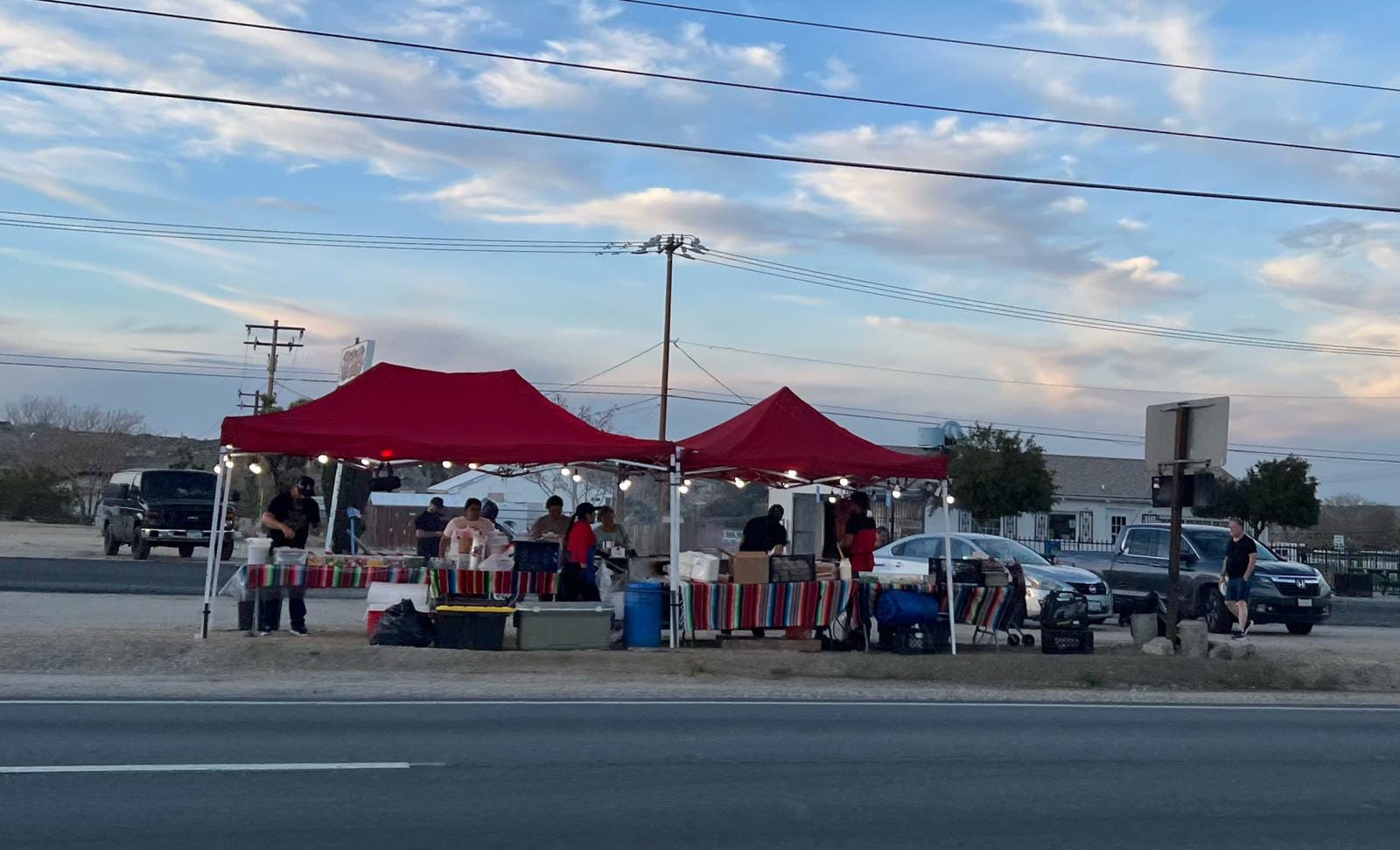
Street vendors, particularly taco vendors, have become a common sight along Hwy 62 from 29 to Yucca Valley. In Twentynine Palms, taco vendors set up near Oasis Cave Market and at the intersection of Utah and Hwy 62. A process for permitting these vendors was enacted by the California legislature with SB 946, also known as the Safe Sidewalk Vending Act. Per Wikipedia, a vendor can be stationary or mobile and is defined as “a person who sells merchandise or food from a pushcart, stand, display, pedal-driven cart, wagon, showcase, rack, or other non-motorized conveyance on a sidewalk or pedestrian path.” The Act effectively decriminalized sidewalk vending and was enacted in 2018 as the Trump administration sought to increase the deportations of undocumented workers with criminal records.5
The responsibility for all food permitting including street vendors is held by the San Bernardino County Department of Public Health Environmental Health Services (EHS). Per the staff report, while a mechanism for permitting exists, not all vendors have them—Code Enforcement has been attempting to address the challenge of vendors that lack permits operating in City limits.
From the County’s perspective this program standardizes procedures, enhances food safety, promotes collaboration and provides support and education to vendors. This agenda item recommends participation in the County’s free online Street Vendor Collaboration Program. From the City’s perspective this enables:
•EHS Inspector direct contact
•Training for City Staff to identify unsafe foods
•Access to data collected regarding unpermitted Street Vendors visits
•Educational Material to distribute to all Street Vendors
•Consistent and effective field operation approach guidelines
The staff recommendation is to participate in the County program.
FUTURE COUNCIL INITIATED ITEMS
Note that the previous item 1, “Revisit allocated funds for the portable showers and Navigation Center,” has been removed from the list.
1. Discussion on the General Plan Update.
2. Discussion surrounding (i) costs to maintain dirt roads verses paved roads; (ii) what is a City maintained dirt road, a non-maintained dirt road, a road that has been accepted by the City, a road that is private and not accepted by the City; (iii) the City's ability and liability associated with the City periodically maintaining non-maintained roads, and (iv) ways residents can bring non-maintained and non-accepted dirt roads to paved rural-road standards ready for acceptance into the City's accepted-and-maintained road list.
3. Shade structures around Freedom Plaza and a possible art fixture with "Freedom Plaza" announcing the location.
4. A review and discussion of fees as it relates to Site Plan Reviews for ancillary uses.
5. Discussion on abandoned homes in the community.
6. Discussion on reorganizing the Homeless and Housing Committee.
7. Discussion on partnering with the Boys and Girls Club.
8. Discussion on reviewing policies for non-profits who receive funding from the City.
9. Discussion of a policy regulating the use of City Attorney resources.
Thanks to Desert Trumpet Administrative Associate Heidi Heard for the parcel research for agenda item 9.
Leave your thoughts in the comments below. Please note that we do not allow anonymous comments. Please be sure your first and last name is on your profile prior to commenting. Anonymous comments will be deleted.
Feel free to share this article!
We have reached our goal of $5,000 in paid subscriptions! We are very grateful for support from our community. We know that many communities in the Morongo Basin are economically disadvantaged, so our coverage will always be free. However, if you have the means to support our work, we always appreciate upgrades to a paid subscription. Your upgrade helps keep subscriptions free for those who cannot afford to donate.
Note: your subscription/donation will be listed as AHA Projects, the name of our fiscal receiver, on your statement.
Per the minutes of the March 11 meeting, Council adjourned to a closed session at 7:16 pm and ended that session at 8:56 pm.
As is now standard with City nonprofit partners, the Desert Trumpet researched the Family Service Association and can provide the following data:
IRS ruling year: 1973
Location: Moreno Valley
Responsible agent: Cheryl-Marie Hansberger
Gross receipts: $28,752,408
Assets: $24,725,931
Bizfile: Good
DOJ: Current — Awaiting reporting
Mission (990): BUILDING COMMUNITY ONE FAMILY AT A TIME, THROUGH COMPASSION, ADVOCACY AND COMPREHENSIVE MODEL SERVICES, FOSTERING SELF SUFFICIENCY AND SUSTAINABLE IMPACTS.
These numbers refer to the map included on item 9, listed are parcels 5 acres and larger:
1. BOB Development, 12 acres, CG
9. Thomas and Janet De Bakker, 5 acres, SFR
12. Olive Rice Trust, 5 acres, SFR
13. Shroff Family Trust, 5 acres, SFR
27. DCR Construction Inc., 7.41 acres, CG
37. Elgon Industries LLC, 10 acres, CG
Pew Research Center, How border apprehensions, ICE arrests and deportations have changed under Trump, March 2, 2020.