
ON THE AGENDA: Twentynine Palms Planning Commission, June 2, 2026
A stretched City Staff is being tasked with arduous General Plan updates, Land Use maps, and zoning complexities.

This upcoming Tuesday, June 2 at 5 pm, the Twentynine Palms Planning Commission will hold its second of many study sessions on the City’s General Plan update. The last General Plan update was finalized in 2012. Due to budget constraints, City staff is conducting the heavy lifting for this arduous process in-house, without outside consultants. At past Council meetings, Mayor Daniel Mintz has admitted that formulating the 2012 General Plan cost the City upward of $1 million.
Relevant Background Information:
The Desert Trumpet has an overview of the City’s General Plan update process here.
Coverage of the last Planning Commission meeting is available here.
A link to the entire 20-page agenda packet is available here.
The General Plan contains eight elements— land use, circulation, housing, safety, conservation and open space, recreation, equity and social justice, and noise. Staff is opting to tackle the Land Use element first, because all other elements are contingent upon it. A ninth element on Art is currently in the works through the Public Arts Advisory Committee.
The Land Use Element & City Zoning Map
In the aftermath of the City’s strategic planning sessions where residents, elected and appointed officials, and community stakeholders had opportunities to outline their long-term goals for the City for the next 5, 10, and 20 years, the City is now taking on its General Plan revisions.
For this study session, Commissioners will review two out of an anticipated 22 Land Use maps. Whether this is the most efficient approach to updating the General Plan is yet to be determined.
The current Land Use Element is 117 pages and contains the City’s zoning map with all of its land use categories and definitions. Listed within that adopted element are ten guiding principles:
Goal LU-1 Encourage orderly growth and development as
envisioned by community residents.
Goal LU-2 Protect existing neighborhoods and the area’s natural
surroundings by encouraging development that is
compatible with the City’s small-town character.
Goal LU-3 Promote a high quality of life by encouraging attractive
high quality development that is compatible with
existing uses and the City’s desert environment.
Goal LU-4 Adequately address the potential impacts of new
development on the existing community and the City’s
infrastructure system.
Goal LU-5 Preserve Twentynine Palms natural resources and
protect the public health, safety and general welfare of
City residents in areas adjacent to potentially hazardous
natural and man-made features and facilities
Goal LU-6 Promote development of a well-balanced community that can adequately meet the needs of future residents and promotes economic development.
Goal LU-7 Protect and preserve Twentynine Palms natural
resources, promote the existing quality of life and prepare for future residents and businesses by promoting superior sustainable development.
Goal LU-8 Maintain Twentynine Palms as a clean and healthy place
to live, while protecting the City’s groundwater supply.
Goal LU-9 Protect the health and safety of residents living in the
vicinity of airports
Goal LU-10 Promote a high quality of life for Twentynine Palms
residents by developing and sustaining a strong and
diverse local economy.
Staff has also laid out “goals” for “reviewing the land use element.” What’s notable here is the framing in the staff report: these are described as “goals that Staff has developed” — it doesn’t say “proposed goals for commission consideration and revision” or “draft goals for community input.” It presents them as already established, with the commission’s role being to work within them rather than shape them. While 1 and 2 read as goals, 3-5 are written as procedures, methods or reminders.
Goal 1: The Land Use Element should be reflective as much as possible of actual real-world conditions; i.e. land use designations should accurately reflect the established lot sizes and actual developments
Goal 2: Where feasible, suggestions for changes to the Land Use designations would reflect achievable long-term development
Goal 3: Where appropriate, new land use districts may be developed – or existing land use districts may be consolidated and simplified.
Goal 4: Historical and environmental considerations also play an important role in developing a Land Use Element;
Goal 5: Each Specific Plan will Be studied for modern relevancy
The General Plan update is the City’s first systematic attempt since 2012 to reconcile what the map says with what actually exists on the ground, with the staff report citing commercial businesses located in residentially zoned areas as one category of interest. Residential lot sizes that do not match their listed zoning type are also being looked at.
Questions for the Planning Commissioners—and the City
For this week’s study session, staff is posing the following questions to Commissioners:
Should an “Open Space - Conservation Land Use District” be created?1
Should a “Utility Land Use District” be created to reflect ownership of the various utilities? Or should their properties be shown changed to the “Public (P) Land Use District”?
Should we have a “One Map” system, where the General Plan Land Use Map and the Zoning Map are the same? Or should we have a “Two Map” system, where the General Plan shows broad categories, and the Zoning Map gives more detail?
Should the “Public” (P) land use designation be more specific? In other words, should there be a difference between those properties used for parks and those used for utilities?
Should the minimum Land Use District size be maintained, or revisited?
A Potential Open-Space Conservation Category
Staff is floating the creation of an Open Space Conservation2 land use district and asking if it is applicable to federally owned properties within City limits:
B) Approximately 126 acres in the far southwest corner of the City boundaries are owned by the Federal Government and are very hilly and topographically difficult in which to build. Should those properties be shown as Open Space - Conservation (OS-C) or Public (P)?
Labeling federally owned land as OS-C signals that conservation matters more than ownership type. Choosing Public (P) acknowledges that the federal government controls what happens there. How the City handles this parcel will likely shape how it treats other environmentally sensitive or government-owned land going forward.
Per the Land Use Element:
The P (public) land use serves as a means of identifying public lands and facilities, such as City and County facilities and offices, schools, libraries, museums, parks, open space lands and other publicly owned lands. Public uses that contribute to and support the needs of the community are allowed in P designated properties.
Lear Avenue & Highway 62 Intersection Improvements Expected
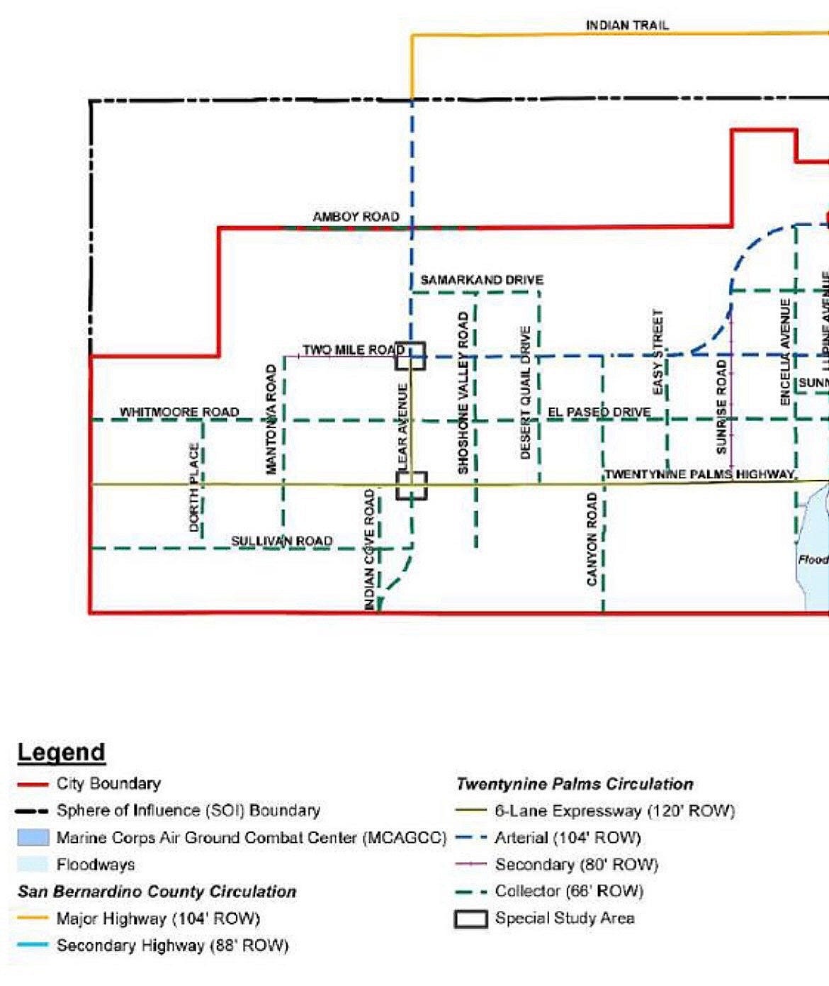
Addressing expected improvements to the intersection of Lear Avenue and Highway 62, the staff report states:
It is anticipated that Lear Avenue may need to be improved in the near future, along with further engineering improvements. It may be prudent to consider a change to the land use designations at that intersection from residential to commercial.
Currently, all parcels on either side of Lear Avenue are zoned as residential. Territory north of Amboy Road is unincorporated San Bernardino County, which is also zoned for Rural Living with 2.5 acre minimums.
The Circulation Element contains the proposed road network of the City General Plan, where road improvement intentions are laid out, addressing how people, goods and resources move throughout the community:
This element primarily addresses the City’s street network which establishes the existing conditions of streets and a Circulation Plan for expanding the street network to service the land uses planned for in the Land Use Element.3
Projected improvements to Lear Avenue are included in the Circulation plan, approved April 27, 2012, which entail that as development along Lear Avenue continues, plans for up to a four-lane improvement are in place, while six lanes are planned for 62. Lear between 62 and 2 mile is marked as a special study area for potential increase to six lanes.
As stated in the Circulation Element, Lear Avenue is one of the City’s main north-south arterial roads, along with Adobe Road, Utah Trail, and Mesquite Springs Road. It also serves as a critical byway for travel to and from the 29 Palms Marine Corps Air Ground Combat Center. Portions north of Amboy Road are unincorporated.
The Community Development Director is asking Commissioners if the land use designations at the intersection of Lear and Highway 62 should be changed from residential to commercial. The justification for this conversion is nebulous, however, with the staff report arguing that converting the land from residential to commercial would “a) minimize potential conflicts with residences in the future; and (sic) 2) encourage the improvements to Lear Avenue in a planned manner.” 4
It should be noted that the Ofland project discussed in Footnote 2 was triggering the paving of Lear between Highway 62 and Sullivan, a point of contention with residential property owners along the proposed improvement. Since the residential properties already exist on the southwest side of the proposed Lear extension, it’s unclear how upgrading the southeast parcel to commercial would ease conflicts.
Questions for Residentially Zoned County Flood Control Properties
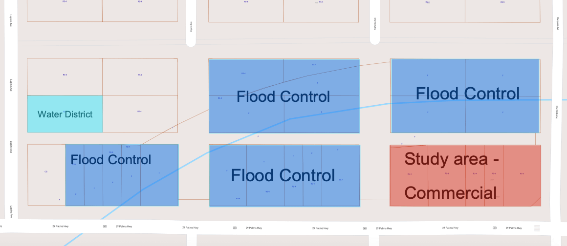
A series of residentially zoned areas fall within San Bernardino County Flood Control jurisdiction:
Flood Control owns several properties that are designated for residential development, and are realistically part of the maintenance area for the major flood control channel. Additionally, there are several commercial businesses in areas zoned for residential. Should these zoning on these properties be modified to reflect the real-world situation?5
Rezoning flood control land and Lear Avenue away from residential could trigger a state compliance problem due to SB330 state housing law requirements. The City would need to identify replacement residential capacity somewhere else if SB 330 is triggered.
Is A General Plan Citizens Advisory Committee Needed?
Whether Gardner's map-by-map approach ultimately produces a genuine vision for Twentynine Palms' future or will simply be a consuming exercise in cartography and staff time may depend on City leadership.
The General Plan approved in 2012 encompasses over 950 pages, including an environmental impact report, and broad categories with impactful implications in terms of future development and guidelines for City leaders to follow with longterm vision in mind.
Advisory committees are common for such processes— the City of Big Bear Lake established a GPAC for its 2025 General Plan update, with members appointed directly by the City Council. Along with hired consultants, the City of San Bernardino also had a citizens advisory committee for its General Plan update in 2020.
In 2022, the City created a General Plan Advisory Committee (GPAC) to advise on its Equity and Social Justice Element the members were Jonas Childs, Korina Cole, Jamie A. Garcia, Gary Horn, Lashara Maea and Mariana Wright-Mills. At a past Planning Commission meeting, resident Kim Ortamond spoke of her participation on a past GPAC where she advised on minimum acreage for horse stables and animal keeping standards.
Acknowledging what this process actually requires before staff gets too far down the road to change course will be up to Council and newly appointed City Manager Kevin Cole to determine. See how it plays out this Tuesday at 5 pm, 6136 Adobe Road.
NOTE: Desert Trumpet staff members Cindy Bernard, Kat Talley-Jones, and Heidi Heard live in the Indian Cove neighborhood, adjacent to this proposed development project, and are on the organizing committees of Indian Cove Neighbors and Say No to Ofland. Read our policy for covering Ofland here.
Hi, new subscribers! Desert Trumpet understands you might not be interested in all of our coverage. That’s why it’s divided into separate newsletters allowing you to opt out of reporting that’s not important to you. For instance, you may want our Education news but not City Hall 29.
Here’s how to opt out: go to your Substack settings, scroll down to “subscriptions,” and select “Edit” for the Desert Trumpet. Simply uncheck the box next to the newsletters you don’t want to receive in your email inbox. You’ll still be able to access all coverage online if you change your mind.
Thanks to you, Desert Trumpet met our $10,000 paid subscription goal!!!
Not a paid subscriber yet? Did you know that paid subscribers receive discounts on our DT Social events and invites to DT Front Porch, intimate discussions featuring local officials and notable residents?
Upgrade to a $50+ paid subscription for a 10% discount.
Upgrade to $100+ for a 25% discount.
Sustaining subscribers at the $250+ level and above receive complementary tickets
Leave your thoughts in the comments below. Please note that we do not allow anonymous comments. Please be sure your first and last name is on your profile prior to commenting. Anonymous comments will be deleted.
This coverage is free - please share!
This language is directly from the Staff Report. The Open-Space Conservation land use category was created with the July 2025 approval of the Ofland Resort. It is still in place as of the date of this article’s publication.
Item E refers to the Ofland development: “As of now, the General Plan Amendment and Rezoning that were part of the Ofland Applications are still reflected per the action of the City Council. It should be noted that the developer’s team has asked that these actions be rescinded. No recommendation of that request is proposed at this time, and will be taken up at a later date under separate actions.” An Open Space Conservation (OS-C) zoning designation was a part of City Council’s approval of the project. Since then, the Ofland Developers have pulled out of the project, leaving the status of the OS-C zoning change in limbo. Stipulations from a public hearing held on April 29 state the City has until July 27, 2026 to rescind the Ofland project’s entitlements, which include the general plan amendment that created the OS-C zoning type. This rescissions must be certified into the public record by August 31, 2026.
Source: City of Twentynine Palms Circulation Element
Source: City Staff Report, page 20.
Source: City Staff Report, page 8