
ON THE AGENDA: Twentynine Palms Planning Commission, June 16, 2026
The Land Use & Zoning saga continues...

Two words have been on the minds of Twentynine Palms planning staff the last few weeks — Land Use. The merry-go-round continues Tuesday at 5 pm as the Planning Commission reviews another set of land use and zoning maps, now totaling four of an anticipated 22 maps as the City dips its toes into its General Plan revamp.
The general plan has the following components—
Land Use
Circulation
Housing (due to be updated in 2029)
Conservation / Open Space
Noise
Safety
Recreation
Equity / Environmental Justice (adopted in 2023)
Because the 2026 City budget has not included money for an outside planning consultant, Community Development Director Keith Gardner has opted to take on the General Plan process in-house for now. So far, Gardner has presented two land use maps in the last two study sessions, as we covered here and here.
At the current rate of discussion, the Planning Commission is expected to continue Land Use discussions for at least another 10 meetings, or five to six months contingent on the schedule.
Aside from approval of last meeting’s minutes, the only item on Tuesday’s agenda is a study session with the following topic: Public / Open Space / Utility / Flood Control on Maps 1-4:
As of now, the procedure is to review each of the area of the City per the existing Land Use Element, then review the goals and policies of the Land Use Element that may need to be updated. The first part of this review will be to determine those areas that may be redesignated as "P", "OS", "U", "F" or "TL"; then identify those areas where real-world situations do not match the current land use designations. When complete, the other elements of the General Plan will then be reviewed.
A copy of the 27-page agenda packet is here. Coverage of the previous Planning Commission study session is available here.
Because the City has not yet begun recording or live streaming its study sessions, those interested in this topic are encouraged to attend in person.1
Study Session #3 - Land Use & the General Plan Update
Opting for a simpler process than the previous meeting, where Commissioners tackled a series of questions for each map, the Community Development Director is focusing on just four potential land use categories for this meeting– P for public, OS-C for Open Space-Conservation, U for Utility owned parcels, and F for properties owned by San Bernardino County Flood Control. Per the staff report:
Instead of suggesting a multitude of changes, only those areas that would be removed from development potential are the subject of this workshop.
In other words, only those parcels that are currently zoned with development potential, such as County Flood Control properties that have residential zoning, will be discussed. One of the city’s goals in this process, per the staff report, is to adjust “land use designations to reflect real-world situations.”
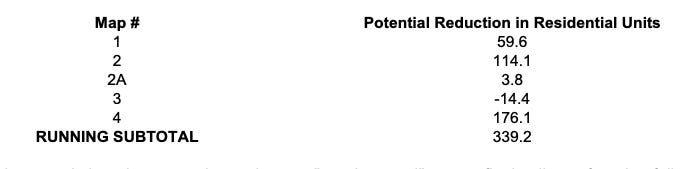
Included in the staff report are calculations for potential changes in residential housing capacity, which the City will need to offset elsewhere to maintain compliance with its Regional Housing Needs Allocation under state no-net-loss law.
Tallying residential zoning losses proposed so far in Maps 1 through 4, if all proposed staff changes go through, the subtotal would be 339.2 potential housing units lost.
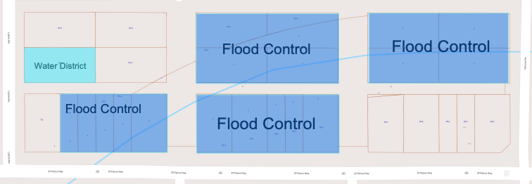
One example of this would be a section of San Bernardino County Flood Control property between Highway 62, Lupine, and Mariposa Avenue, shown above in blue. Currently zoned as residential, the City is suggesting that the land use here be changed to F for Flood Control. If the change takes place, overall residential housing capacity decreases.
What has been mapped so far?
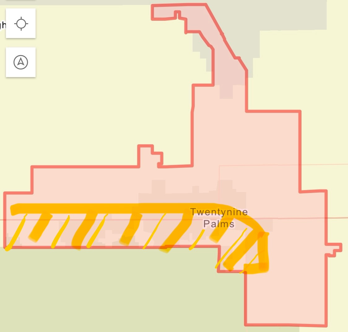
Areas circled in yellow in the image above have been mapped by City staff with proposed zoning changes. Maps 1 and 2 include a federally owned parcel in the far southwestern section of town, the Indian Cove neighborhood, and a county-owned section of flood control property adjacent to John’s Place. Maps 3 and 4, which cover Smoke Tree and Theatre 29, are the eastern continuation of maps 1 and 2.
All four maps have proposed zoning changes. After this meeting, there is an expected 18 maps left for Commissioners to sift through.
At the June 9 City Council meeting, public commenter Paul Nugent called upon Council to allow the Planning Commission to establish a citizens advisory committee for its General Plan:
Our community includes individuals with valuable expertise and experience who can provide insight on land use, zoning development and other planning issues.
And for that reason, I would like to suggest that the city council authorize the planning commission to establish a citizens advisory committee to assist with the general plan update. When the general plan was last amended, the city created a 12 member general plan advisory committee to help gather community input and provide recommendations. A similar approach would ensure that the current update benefits from broad public participation and the diverse perspectives of our residents.
Map 3 - Hatch Road & Knotts Sky Park
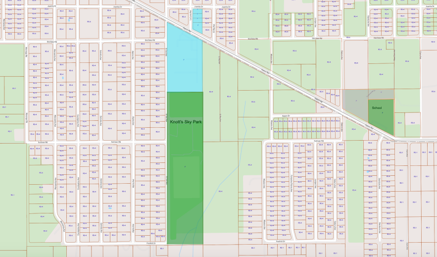
Map 3 focuses on the Smoke Tree neighborhood, which includes Knotts Sky Park, headquarters for the Twentynine Palms Water District (in light blue), Monument High School, and single-family residential neighborhoods zoned RS-4, which allows a maximum of four units per acre.2
North and West of Monument High School is a private parcel zoned as (P) for public with a gray color coding labeled “Study Area.” Because it is a privately owned parcel, its current Public zoning is not appropriate as it is not owned by the city or a government entity. Staff is suggesting this parcel be changed to a different designation. Further details on the parcel, such as ownership information, are not included in the agenda packet.
Map 4 - Sullivan Road, Palms N Paws, Public Works, Theatre 29, Reset Hotel
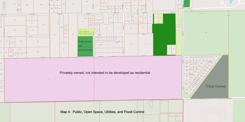
In continuity with Map 3, Map 4 encompasses the eastern developed portion of Sullivan Road up to Adobe Road. Map 4 introduces the first appearance of Tribal Lands (TL) in the series, reflecting an area across the Casino that is now under jurisdiction of the Twenty-nine Palms Band of Mission Indians.
This map includes the City’s Public Works building, Palms-N-Paws Animal Shelter, and Theater 29, all of which are City owned properties. In pink is a large private property tied to Reset Hotel, which is labeled as not intended to be developed as residential.
According to the housing chart calculations, proposed changes to Map 4 would entail a reduction of 176 in potential housing units.
The meeting takes place at 5 pm, 6136 Adobe Road. See you there!
Hi, new subscribers! Desert Trumpet understands you might not be interested in all of our coverage. That’s why it’s divided into separate newsletters allowing you to opt out of reporting that’s not important to you. For instance, you may want our Education news but not City Hall 29.
Here’s how to opt out: go to your Substack settings, scroll down to “subscriptions,” and select “Edit” for the Desert Trumpet. Simply uncheck the box next to the newsletters you don’t want to receive in your email inbox. You’ll still be able to access all coverage online if you change your mind.
Thanks to you, Desert Trumpet met our $10,000 paid subscription goal!!!
Not a paid subscriber yet? Did you know that paid subscribers receive discounts on our DT Social events and invites to DT Front Porch, intimate discussions featuring local officials and notable residents?
Upgrade to a $50+ paid subscription for a 10% discount.
Upgrade to $100+ for a 25% discount.
Sustaining subscribers at the $250+ level and above receive complementary tickets.
Leave your thoughts in the comments below. Please note that we do not allow anonymous comments. Please be sure your first and last name is on your profile prior to commenting. Anonymous comments will be deleted.
This coverage is free - please share!
The City has until July 1 to comply with a state mandate requiring that City meetings be recorded for public record
Source: 29 Palms Code of Ordinances