
RECAP: Twentynine Palms Planning Commission, June 2, 2026
Planning Commission discusses zoning changes and formation of a General Plan Advisory Committee.

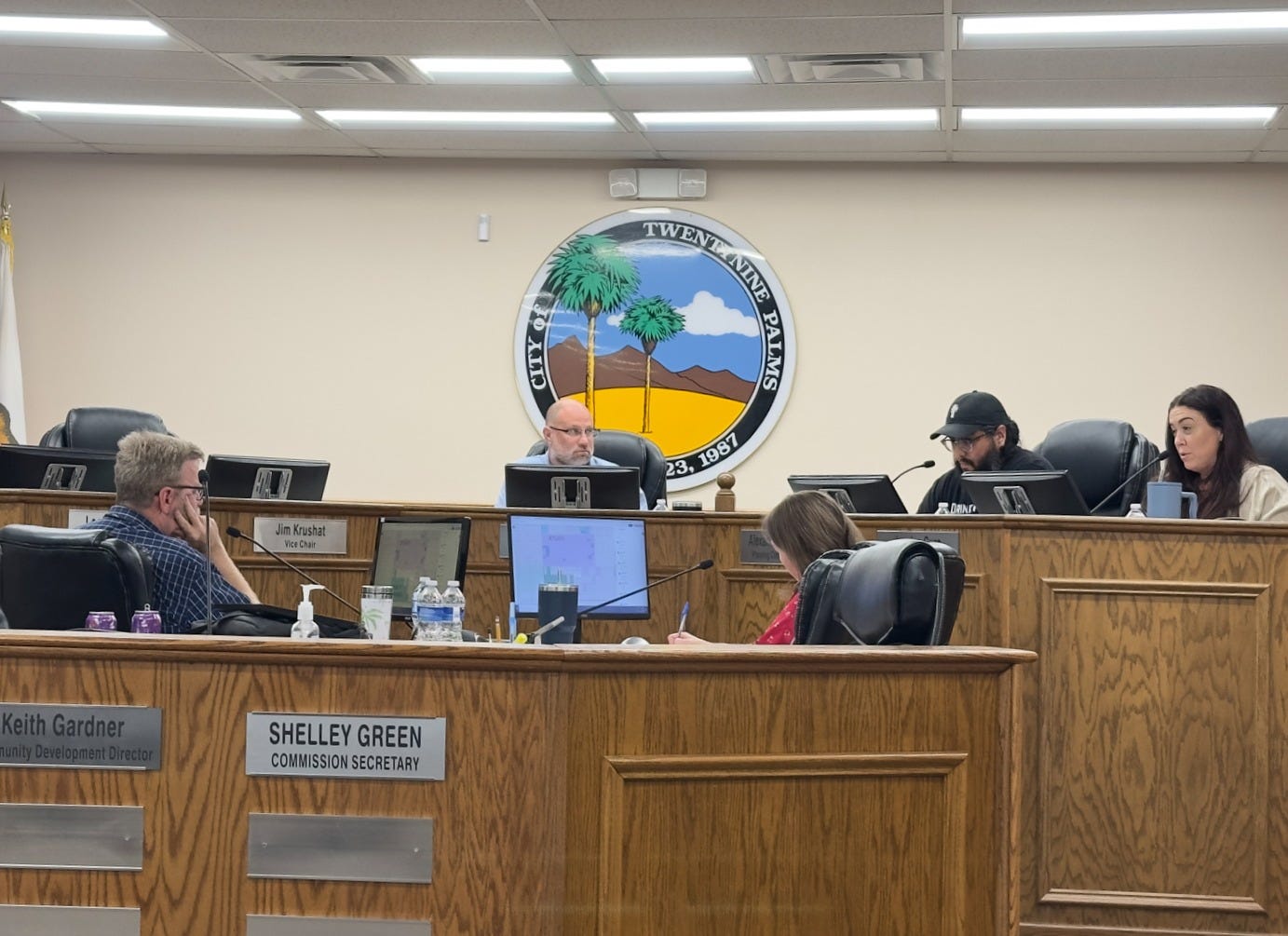
This last Tuesday, June 2, the Twentynine Palms Planning Commission held a study session on General Plan updates. They analyzed two Land Use maps and discussed zoning intricacies in southwestern portions of the city. Three of five Commissioners were present with Vice Chair Krushat and Commissioner Paahana having excused absences.
The meeting was just under an hour. Commissioners sifted through a series of questions on utility owned parcels, residential properties that do not meet their current zoning criteria, and potential zoning changes of federal properties.
The agenda packet is here. Coverage of the meeting agenda is available here. The first 4:28 minutes of the meeting is available here, though the study session was not recorded. Per state requirements, the City has until July 1 to begin recording and livestreaming all workshops, study sessions, committee meetings, and board meetings.
PUBLIC COMMENT
None
STUDY SESSION: Study Maps 1 and 2 of the General Plan Update


The City General Plan is past due for an update. City Staff is conducting the beginning stages of this lengthy process in-house, without consultants, starting with the Land Use element. The Land Use element contains the zoning map for the City, and defines the various land uses and districts within that zoning map, from residential to commercial, rural to public, and everything in between.
City Staff is starting this process by analyzing sets of the City’s land use maps, with an anticipated 22 maps in total. For this study session, commissioners had two maps to analyze with a set of questions and considerations to discuss. They included the question of retaining the Open Space-Conservation (OS-C) land use type, which was created through a Conditional Use Permit to facilitate the development of the Ofland Resort project.1 Other questions included federal property zoning designations and the land use designations of property owned by utility companies such as Southern California Edison and the local water district.
Community Development Director Keith Gardner kicked off the study session:
There is no timeline to this, but the general plan does need to be updated, and this is going to be a slow process. We want to make sure we get it done in a thorough process as we can.
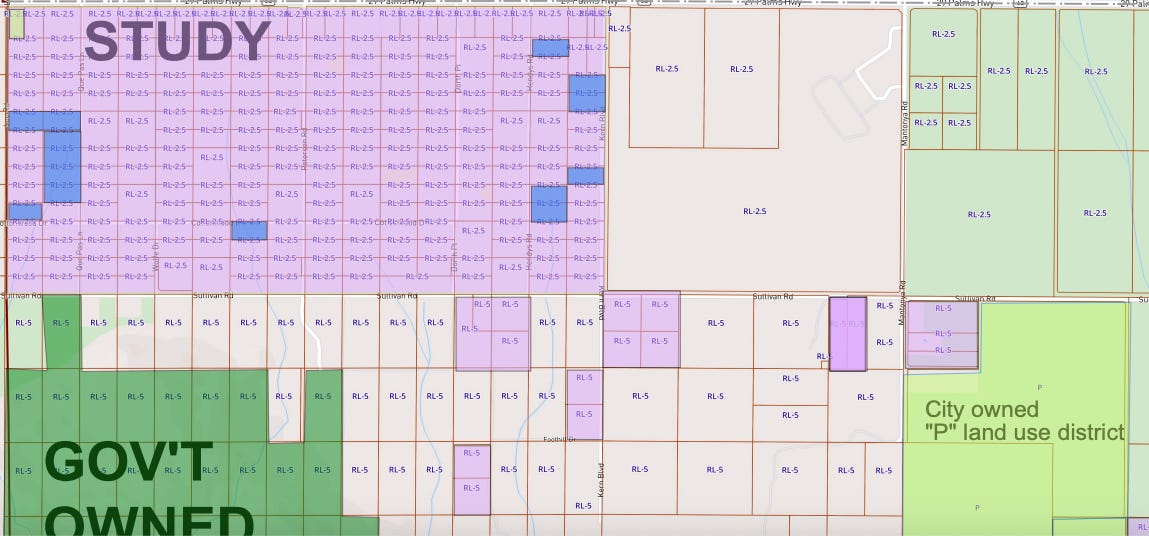
Map 1 displayed a series of five-acre residential lots owned by the federal government and a handful of lots owned by County Flood Control and the Twentynine Palms Water District.2 Also on the map was a purple section labeled “STUDY AREA” in which a series of undeveloped residential lots did not meet the correct lot size for their current zoning.
Gardner posed the following questions to Commissioners regarding Map 1:
Should those properties in the area bounded by Highway 62, Lee Road, Kern Boulevard, and Sullivan be redesignated to reflect actual lot sizes?
Should those properties owned by the federal government be redesignated as “P” or “OS-C”?
Should properties that are inconsistent with their land use designation be considered for redesignation?
Should all properties owned by the City be shown as “P” or should that be on a case-by-case basis?
Should a consideration be made to redesignate a portion of the properties at intersection of Lear Avenue into a commercial land use designation?
A southwest portion of the city, between Kern Boulevard, Lee Road, Sullivan Road, and Highway 62, highlighted in the map above, contains an area of one-acre residential lots that are zoned for 2.5 acres, a mismatch Gardner attributed to government survey lots that were likely grandfathered when the City incorporated.
The commission agreed to address these mismatched zoning areas on a case-by-case basis. Cure inquired on the history of the lots and argued that isolated parcels sandwiched among larger ones don’t necessarily warrant a blanket redesignation.
Chair Max Walker and Commissioner Alex Garcia were in agreement that the map should match what’s on the ground as much as possible.
Regarding designation of federal property as P for public or OS-C, Commissioners and City Staff emphasized that the City has very little jurisdiction over what the federal government can do with its own land though the land is not appropriately zoned for residential use as it is too difficult to develop.
Though commissioners were generally in favor of retaining the Open Space Conservation (OS-C) land use designation, Commissioners stopped at wanting to apply that designation to federal properties. Chair Max Walker asked if a lawsuit on the Ofland development was why the OS-C land use was no longer in play. Gardner confirmed:
We have a request from their attorney to rescind all Ofland [zoning], including the establishment of the open space conservation zone.
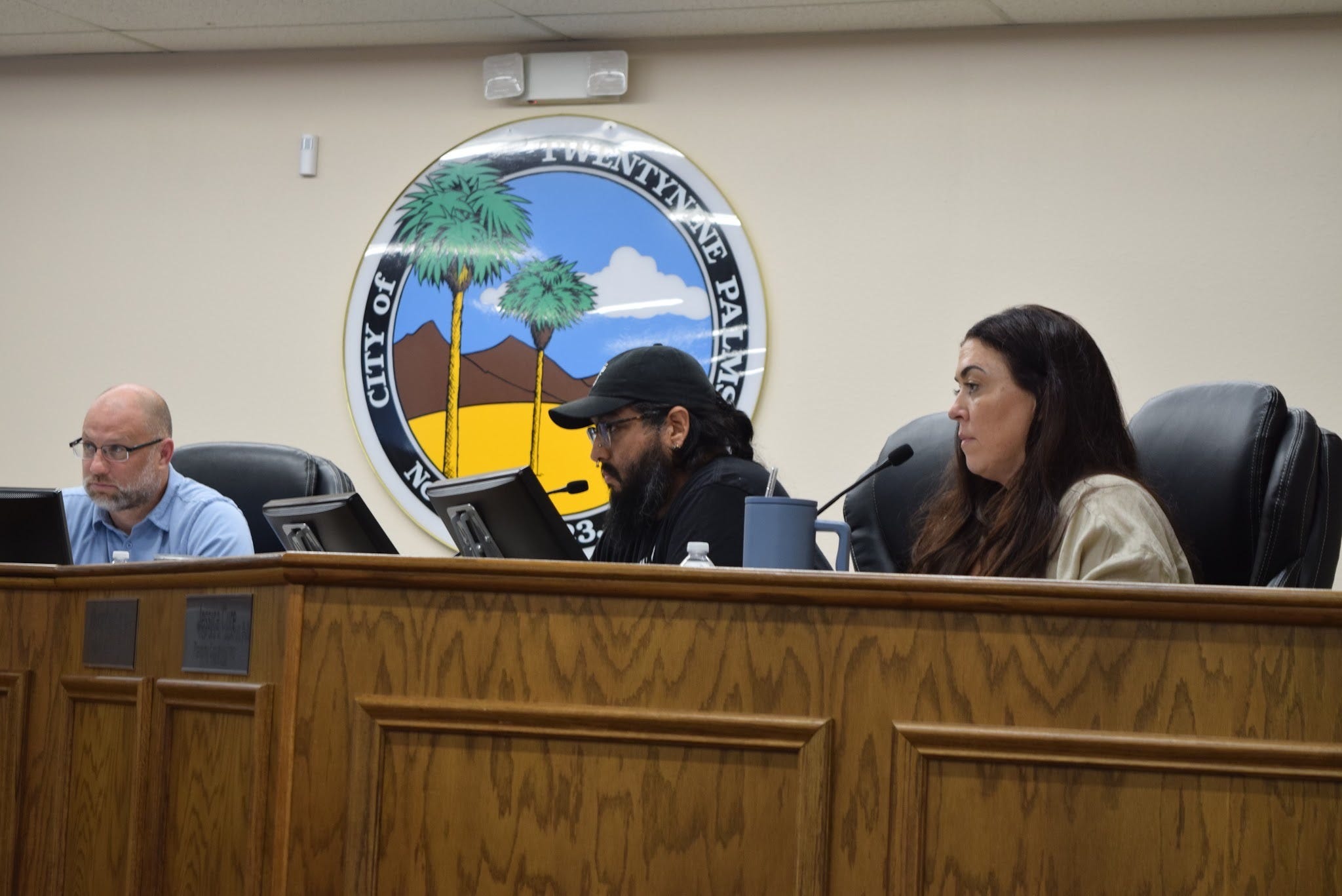
Commissioner Cure was in favor of designating federal land and City-owned land as Public (P) and that utility-owned parcels should be in their own separate category. Garcia was also in favor of utilities having their own separate category and inquired if the Public land use designation can be subdivided into more specific criteria.
Cure stated:
If it’s conservation, then it should be conserved and nothing else — zero grading. So it wouldn’t necessarily be applicable to some of the state or federal [land].
Gardner and Walker both acknowledged that any conversion of residential property to a different land use designation would have to accommodate state requirements. Government Code Section 65863 — the no-net-loss statute prohibits reduction of residential density below a required threshold unless replacement sites are identified.
Property owners would also have to be notified by the City before any zoning changes are implemented.
Will There Be A General Plan Advisory Commission?


Speaking from the public was Cindy Bernard, who called for the formation of a citizens advisory committee:
Why are we starting this conversation without a citizen advisory committee? There's always been a citizen advisory committee for any General Plan work we've done, and yet, for some reason, we don't have one now. We had a citizen advisory committee when we revised the STR ordinance. I don't know why we don't have one for the general plan, so I'm putting that to you to please discuss, because I think it's absolutely necessary. It'll be a mistake to do this process without a citizen advisory committee.
Because this was a study session, Commissioners were able to respond to concerns raised in public comment. Chair Walker drew from his experience working on the Marine Base master plan revisions and was ultimately receptive to the formation of an advisory committee:
For the citizen advisory thing, my experience with this — on the base, we didn't bring the base population into the conversation for a little while, while we worked through kind of how we wanted to approach updating the Base master plan. I don't necessarily know if we're there yet with where we're at in the process. I think we're just kind of working through some general thoughts and ideas.
Gardner said he was open to public input if Council chose to go that direction. Walker clarified whether or not the Planning Commission has the authority to create a committee:
Until the Council directs us to set up the advisory committee, I think coming to the meetings, which we greatly appreciate, and giving your input, is kind of where we're at, and that's where we're going to go from there.
Sitting in the audience was newly appointed City Manager Kevin Cole. Walker added:
I think, by me saying this right now with the new City Manager in the audience, I am asking for at least the conversation to be brought up to the City Council.
Map 2 - County Flood Zone Properties
Map 2’s discussion involved County flood zone properties east of Stater Bros and west of John’s Place. A handful of businesses are in this residentially zoned area— Commissioners agreed that they should be converted to reflect their commercial business and that flood zone property should have its own Land Use designation.
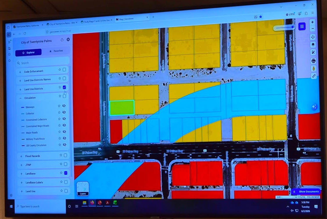
Lear Avenue & the Circulation Element
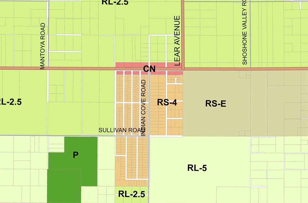
Within the staff report was an inquiry on anticipated development for Lear Avenue and Highway 62. Zoned for 2.5 acre lots, Gardner said there are two parcels on the southern side of the Lear/Highway 62 intersection (in Indian Cove) that are zoned neighborhood commercial. The item asks whether the four parcels at the intersection of Lear and 62 should all be commercial instead of residential.3
Bernard raised objections to Gardner's suggestion that parcels at the Lear Avenue and Highway 62 intersection could be reconsidered for a commercial designation:
We just fought very hard to make this parcel residential and not commercial. I think you’re going to find a lot of residents very upset if you take that back to commercial.
Bernard also identified what she called an inconsistency with Lear Avenue’s extension being triggered by development of the southeastern parcel on Highway 62 and Lear instead of the southernmost parcel between Sullivan and Baseline. Highlighting the Circulation Element, Bernard pointed out:
Why is the extension of Lear triggered by development on this [northern] parcel, when the whole point is — it’s supposed to go all the way up into this [the southern] parcel, per the circulation element.
Gardner said he would consult the city engineer when the commission reaches the Circulation Element portion of the review — including whether all general plan roadways are still needed as currently drawn.
Community Development Director Update
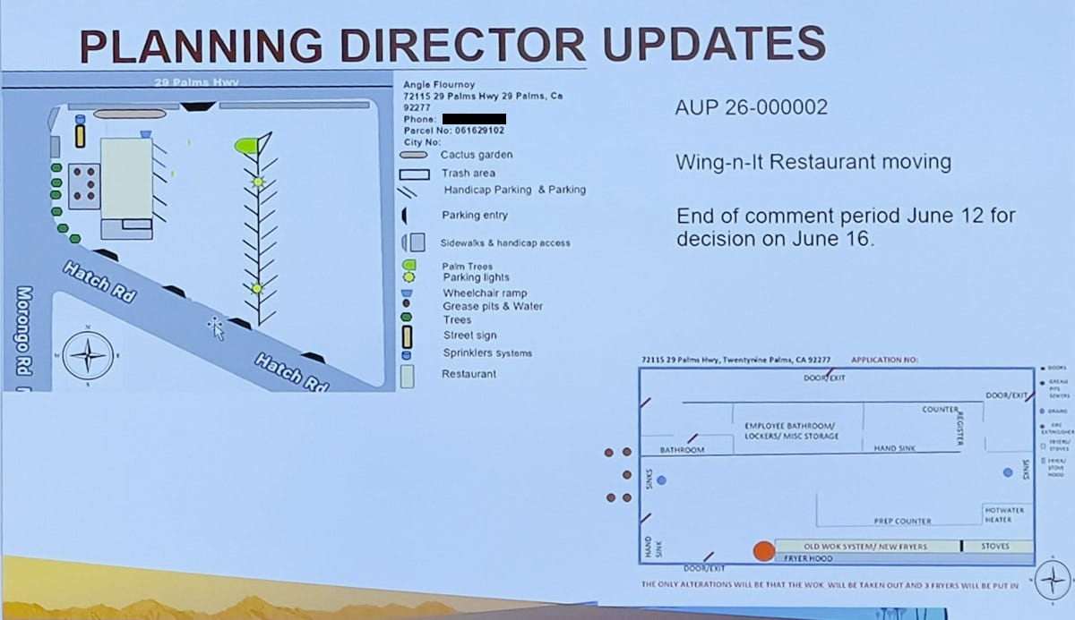
Director Gardner informed the Commission of a request from Wing-N-It to move from its current location at 72317 29 Palms Highway, to a location just west of that between Hatch Road and Highway 62, at 72115 29 Palms Highway. The moving plans showed blueprints with a cactus garden in the front and outdoor seating. The comment period ends June 12 with the staff expected to decide on the relocation application June 16. Because the move requires only an Administrative Use Permit (AUP), the approval decision is delegated to the Community Development Director. To comment on the Wing-N-It application, write to kgardner@29palms.org.
Gardner said the commission would have at least one more general plan workshop in two weeks, may have development applications coming up in July, and is potentially looking at a development code update for accessory dwelling units to better reflect changes in state law. The July 21st meeting was cancelled after all three commissioners present indicated conflicts that day.
The next Planning Commission meeting will take place June 16 at 5 pm.
NOTE: Desert Trumpet staff members Cindy Bernard, Kat Talley-Jones, and Heidi Heard live in the Indian Cove neighborhood, adjacent to the Ofland development project, and are on the organizing committees of Indian Cove Neighbors and Say No to Ofland. Read our policy for covering Ofland here.
Hi, new subscribers! Desert Trumpet understands you might not be interested in all of our coverage. That’s why it’s divided into separate newsletters allowing you to opt out of reporting that’s not important to you. For instance, you may want our Education news but not City Hall 29.
Here’s how to opt out: go to your Substack settings, scroll down to “subscriptions,” and select “Edit” for the Desert Trumpet. Simply uncheck the box next to the newsletters you don’t want to receive in your email inbox. You’ll still be able to access all coverage online if you change your mind.
Thanks to you, Desert Trumpet met our $10,000 paid subscription goal!!!
Not a paid subscriber yet? Did you know that paid subscribers receive discounts on our DT Social events and invites to DT Front Porch, intimate discussions featuring local officials and notable residents?
Upgrade to a $50+ paid subscription for a 10% discount.
Upgrade to $100+ for a 25% discount.
Sustaining subscribers at the $250+ level and above receive complementary tickets
Leave your thoughts in the comments below. Please note that we do not allow anonymous comments. Please be sure your first and last name is on your profile prior to commenting. Anonymous comments will be deleted.
This coverage is free - please share!
As noted in our coverage here, the City has until July 27 to rescind the zoning for the Ofland Resort. The developer abandoned the project in late April 2026.
Gardner did not specify which federal entity owns this property.
The southeastern parcel of Lear Avenue and Highway 62 is currently zoned as open space and tourist commercial due to the Ofland Project.
There are many issues facing our city that are far more important than wrestling over residential land use designations (zoning) because existing properties don’t meet the current zoning code. There are hundreds of, maybe thousands of parcels that were legally created but don’t match the underlying zoning. And if they solve this problem, what have they accomplished? Nothing. It is a complete non-issue.