
ON THE AGENDA: Twentynine Palms Planning Commission, December 16, 2025
Study sessions, General Plan discussions, land use and zoning designations open to changes


2025 wraps up with the Twentynine Palms Planning Commission holding three study sessions. Study session topics include updating the list of City-maintained roads, feedback on updating the General Plan, and potential updates to the City’s allowable land use policies. The meeting takes place at 5 pm at 6136 Adobe Road.
The 24-page agenda packet is available here, and coverage of the last Planning Commission meeting is linked here.
PUBLIC COMMENTS
After Planning Commission announcements, residents can comment on items not on the agenda. Public comments on agenda items will be requested when the item is discussed. Fill out a green comment sheet for public or agenda item comments and hand it to the staff, usually sitting at the desk at the front of the room on the right side. Residents have three minutes to make your comments.
You may also email comments to Planning Commission members and Community Development Director Keith Gardner and request that comments be read at the meeting.
CONSENT CALENDAR
The only consent calendar item is approval of the November 4 meeting minutes.
PUBLIC HEARINGS
NONE
STUDY SESSION
2. Update for Maintained Road List
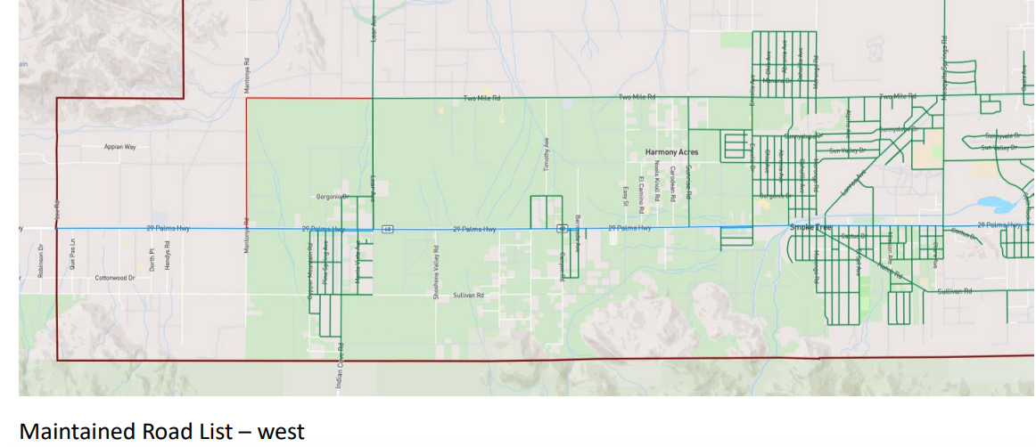
The City is required to keep a list of maintained roads, and they update it periodically. Twentynine Palms inherited this list from the County of San Bernardino when it incorporated back in 1987. Upgrades to Highway 62 are under CalTrans jurisdiction.
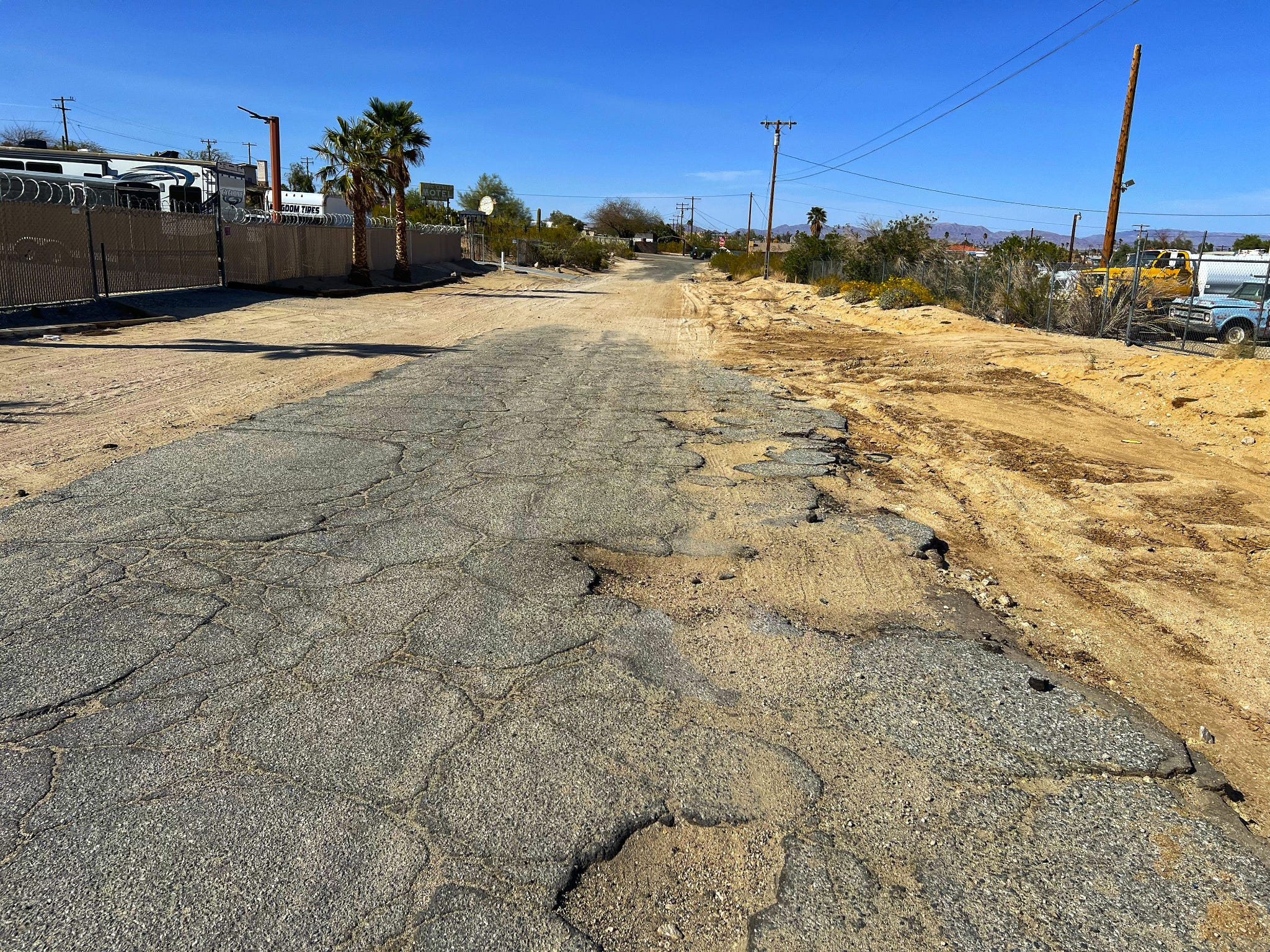
One would think that all roads within the City, unless they are private, would be maintained by City public works crews. However, in Twentynine Palms this is not the case. Take the south end of Pine Avenue, for instance, a paved road within City limits that is not maintained by the City. Despite the City’s public works office being just up the road from Pine Avenue, on Bullion, and City vehicles needing to travel this road daily, the road itself is pitted with potholes.
The Desert Trumpet covered this issue extensively in April 2025 when Planning Commissioners were reviewing the City’s maintained roads list to submit for later Council approval.
At the time, City Staff reports and Community Development Director Keith Gardner said that the City does not anticipate the addition of any more roads to this list. However, a map of City-maintained roads shows that there are large swaths of roadway that the City could potentially add to its maintained roads list if it wishes to do so. For example, a map of City maintained roads shows sections of Harmony Acres, Indian Cove, and certain streets west of Theatre 29 are not on the list.
To qualify, a street must have all rights-of-way dedicated to the City.
When it reached City Council, Councilmember Octavious Scott suggested that the City should be maintaining all public roads within city limits. Typically, road repairs are paid for with a mix of funding from San Bernardino County Measure I funds, which is a half-cent sales tax that goes toward transportation improvements, state grants, and city money.
Do you have a street in mind that you think should be added? Discuss our roads in the comments below.
3. Update on Thought Process of Updating the General Plan
The General Plan was formally updated in 2012. Similar to how the San Bernardino County General Plan dictates long-term policy goals looking toward the future of the County, the City of Twentynine Palms General Plan contains comprehensive policies with long-term vision for the City. It encompasses categories such as the Land Use Element, Housing Element, Safety Element, Conservation and Open Space Element, Noise Element, and Recreation Element.
From the City website, the General Plan seeks to emulate the following five principles:
Promote a high quality of life while preserving the City’s desert, small-town feel.
Encourage high quality development compatible with the Joshua Tree National Park, Marine Corps Air Ground Combat Center and the City’s desert, small-town character.
Develop a strong and diversified local economy with a focus on arts, cultural, tourism, retail, job growth and overall quality of life for all community members.
Preserve the desert environment and its natural and cultural resources for future generations.
Promote sustainable and adaptable growth principles in the development of the City.
As reported by the Desert Trumpet in August 2025, the City is looking to review and revise its General Plan.
Community Development Director Gardner has cited woes on the City’s behalf, since the City’s land use and zoning ordinance was adopted from the County’s original zoning for the area prior to the City’s incorporation in 1987. According to the City staff report, some of this zoning “may or may not be appropriate.”
Two main examples, there is a large area on the west side of the City that has 1-acre lots that are zoned for 2 1/2 acres. Another large area on the east side of town is owned by the Federal Government that is zoned for residential development
A neighborhood between Lee Road and Kern Boulevard consists largely of one-acre residential parcels, despite being zoned for 2.5 acres. City staff is also proposing that federally owned land east of town be re-designated from residential to Open Space Conservation.
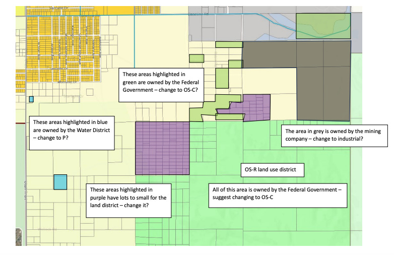
The specific federal agencies that own these parcels—such as the Bureau of Land Management, National Park Service, military, or another federal entity—were not identified in the staff report.
The Open Space Conservation (OS-C) designation is a relatively new category of zoning in the City, introduced in connection with the Ofland Resort development on privately owned land in the Indian Cove area.
Despite these federally owned parcels falling within City limits, the Supremacy Clause of the U.S. Constitution limits the City’s authority to regulate federal land. As a result, any changes the City suggests would likely function as a non-enforceable General Plan land use designation rather than full-blown rezoning.
While the City does not have regulatory authority over federally owned property, the proposed General Plan amendment would re-designate these areas as an Open Space Conservation land use category to better reflect existing conditions and long-term City policy.
This aligns with the General Plan’s fourth guiding principle: to “preserve the desert environment and its natural and cultural resources for future generations.”
Although extremely rough desert terrain, the land could one day be developed if the federal government really wished to do so, although it would be expensive. If the land were to change hands or be sold to a non-federal entity, then the City could potentially have further leverage with enforcement of a rezoning.
In June of this year, the U.S. Senate considered a mass sell-off of federal public lands, which would have made thousands of preserved acres in the Morongo Basin area open to buyers.
From a practical standpoint, a conservation designation falls in line with the area’s adjacency to Joshua Tree National Park more than a federal housing complex.
Thankfully, lawyers and consultants can assist with navigation of these multi-agency land use designations, which the City intends to hire for this lengthy General Plan update process.
4. Possible Updates on Allowable Land Uses
City Staff is suggesting some revisions to the City’s allowable land use permit policy due to language inconsistencies. The current policy, as written, only applies to new construction, which city staff says can make the permitting process complicated and burdensome for small businesses that are moving into buildings that already exist.
There are four types of permits that apply to Allowable Land Uses:
A conditional use permit (CUP) costs $5,000 and needs to be approved by the Planning Commission
An Administrative Use Permit (AUP) costs $2,500 and is approved by the Community Development Director
A Site Plan Review costs $1,250 and is approved by City Staff
A zoning clearance, approved by staff at no cost
City Staff is suggesting a consolidation of the policy to streamline the approval process. For instance, instead of breaking up allowable land uses in Financial Services into smaller categories of banks/credit unions, check cashing/payday advance, and mortgage/lending categories, which require a mix of AUPs and CUPs, staff is suggesting to simplify this all under one “General Office” category instead.
For businesses that are moving into already existing buildings, staff is suggesting language revision to ease costs and cut red tape for small businesses:
If there is (was) an active business license in the commercial space within the last 12 months, then a new business may occupy the space without a new permit as long as it was a ‘like’ business - i.e. bank moving out and a real estate office moving in.
If there is no active business license, then the new business would be required to file for a new land use permit, but it may be reduced in land use intensity. For instance, a new book store going into a vacant building / tenant space would normally be required to provide a Site Plan Review, but would instead be required to get a Zoning Clearance.1
The meeting takes place at 6136 Adobe Road at 5 pm — see you there!
Leave your thoughts in the comments below. Please note that we do not allow anonymous comments. Please be sure your first and last name is on your profile prior to commenting. Anonymous comments will be deleted.

Going into the 2026 elections, Desert Trumpet has sustained a potential 50% cut in funding. Help us provide the coverage you’ve come to expect by becoming a paid subscriber or upgrading your paid subscription today!
Feel free to share this article!
Help us reach our 2025 goal of $10,000 in subscriptions! Upgrade to a paid subscription for just $5 per month or $50 per year.
We are facing a potential $30,000 loss in funding for 2026. Would you care to donate more than $100? Our Paypal account is up and running!