
RECAP: Twentynine Palms Planning Commission, June 16, 2026
To offset residential housing capacity loss, City staff suggests density changes.

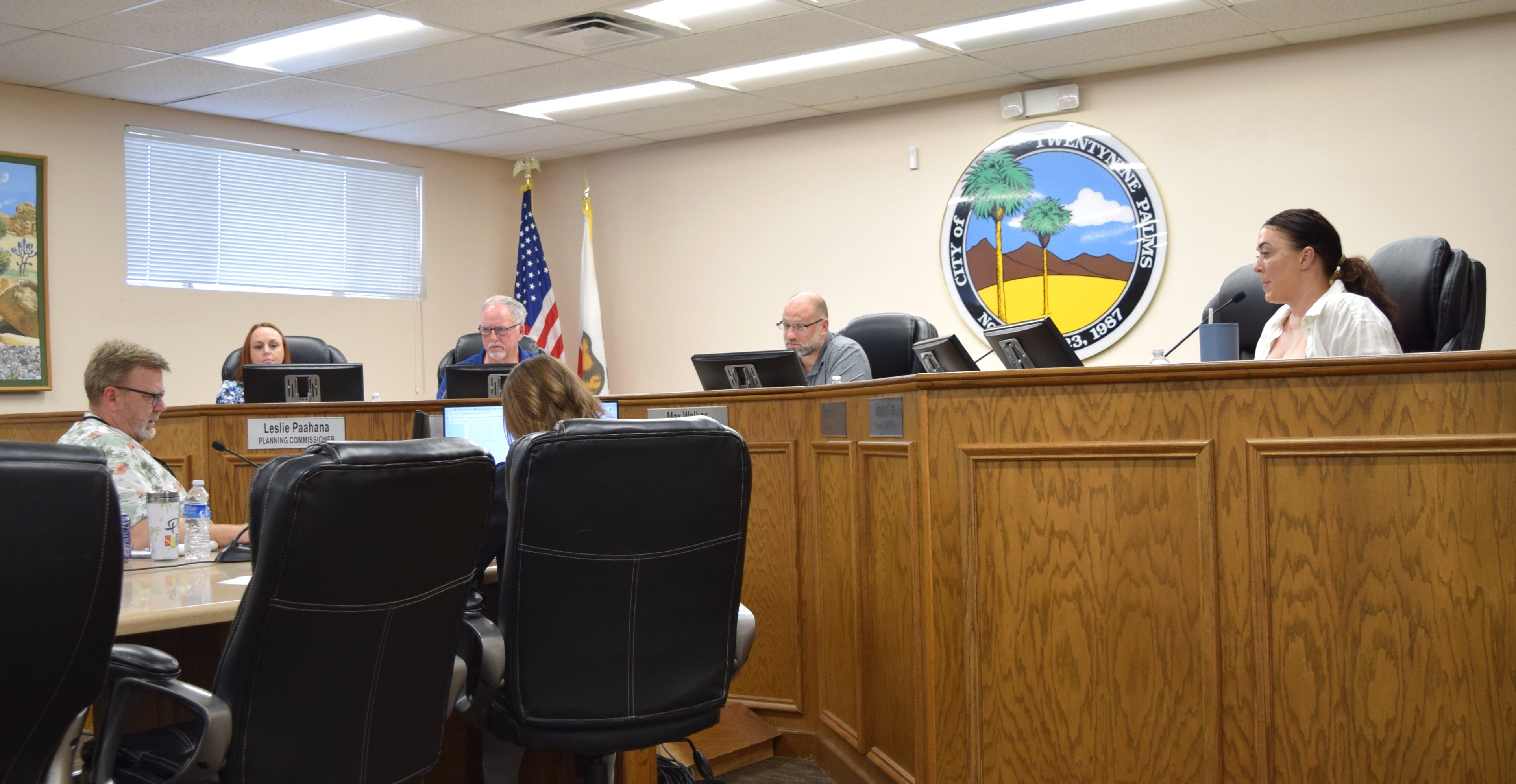
This last Tuesday, June 16, the Twentynine Palms Planning Commission held a regularly scheduled meeting where they hosted a study session on continued Land Use and General Plan discussions.
Four of five Commissioners were present with Commissioner Alex Garcia having an excused absence. This study session was the third of many as the City takes on the initial stages of its General Plan rewrite in-house.
The City of Barstow, similar in size to Twentynine Palms with a population of 25,000,1 just approved its latest 2048 General Plan this month. This followed a five-year process that entailed numerous town hall discussions, advisory committees, stakeholder roundtables, community surveys, and focus group sessions.
Coverage of the agenda packet is available here; the first four minutes of the meeting are available here. The study session, which lasted just under an hour, was not recorded by the City.2
PUBLIC COMMENT
None
STUDY SESSION - Public / Open Space / Utility / Flood Control on Maps 1-4
The Process
The General Plan is a legally required document that every California city and county must maintain. It covers seven mandatory elements: Land Use, Circulation, Housing, Conservation, Open Space, Noise, and Safety. Twentynine Palms has also added Recreation, Equity and Social Justice, and is in the process of adding a final element— Arts.
For pertinent background information, our previous General Plan coverage is available here:
The City inherited most of its zoning from San Bernardino County back when it was incorporated in 1987 and retains inconsistencies that City staff is attempting to sort as part of its General Plan rework— residential parcels owned by utility companies, County flood control, federal agencies, and tribal territory, lot sizes that don’t match actual zoning designations, and zoning that does not reflect what’s physically on the ground, such as commercial businesses in residentially zoned areas.
During the previous study session, Commissioners sifted through a plethora of questions regarding specific land use types, utility owned parcels, and neighborhoods with mismatched zoning acreages on the southwest end of town. The approach was to go map by map and present all potential changes at once — off-limits parcels, real-world mismatches, and future development potential together.
At the last workshop, Commissioners provided city staff with direction on the following:
Properties owned by federal, state, county, or private/non-profit organizations for the purposes of conservation should not be shown as having development potential by the City.
Properties owned by utility companies should not be shown as having development potential by the City.
Parcels owned by County Flood Control should be converted to the “F” land use designation.
Parcels owned by the City will be considered on a case-by-case basis for redesignation, depending on the intention of that property.
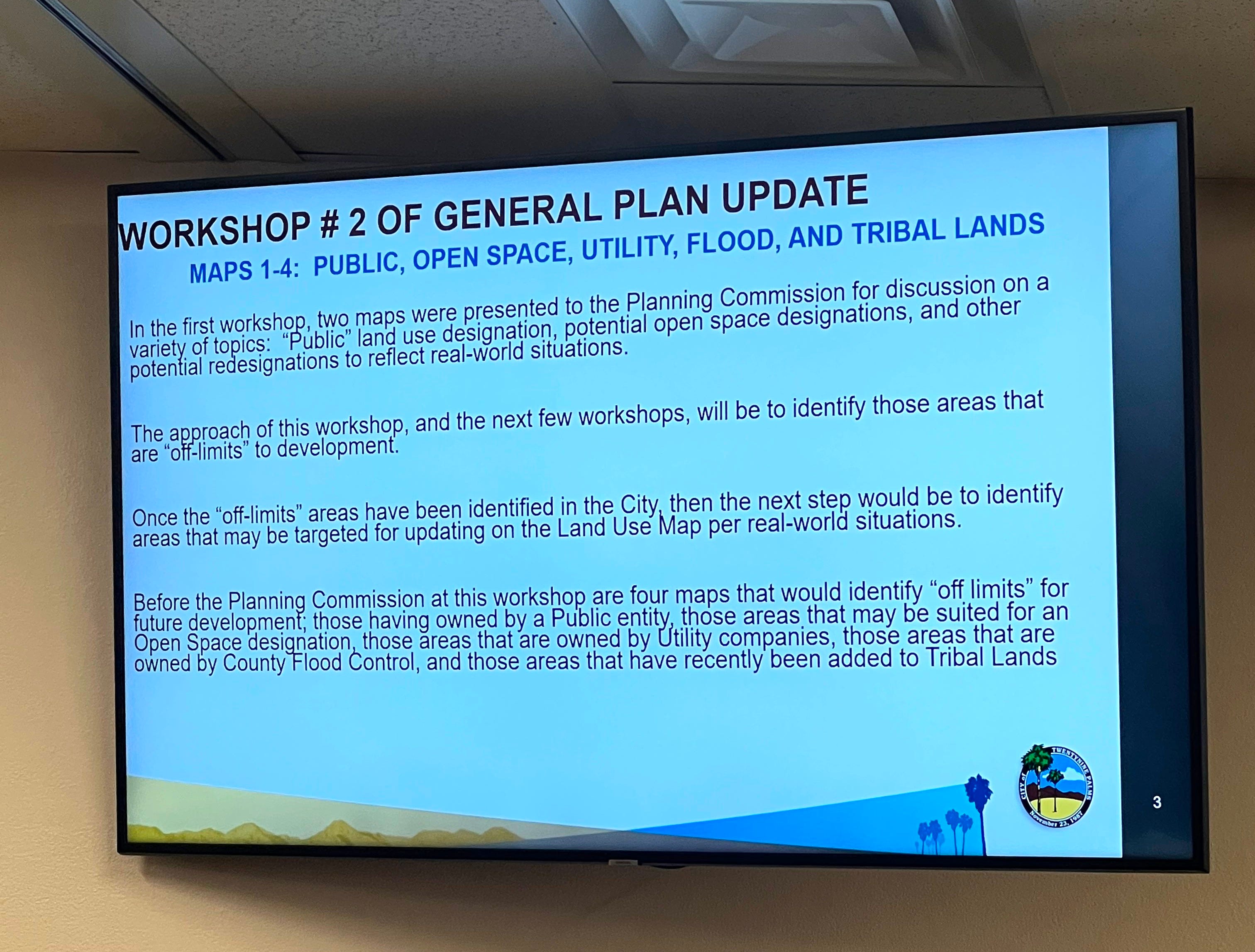
For this meeting, Community Development Director Keith Gardner shifted to tackling the “off limits” category first across all maps before moving to the other categories. The reasoning was sequencing: establish what cannot be developed (federal land, utilities, flood control, tribal lands) before wrestling with what should be developed or redesignated. Gardner described these as areas representing “optimistic developments” that would realistically never be built on regardless of their current zoning.
At the end of the presentation, Gardner posed a methodology question directly to the commission — did they want to keep doing the off-limits pass first, or go back to the all-at-once approach? Krushat and Walker both said they preferred the off-limits-first approach, and Cure agreed. Gardner said the streamlined focus would likely let them move faster, expecting to cover at least four maps per session going forward.
The Commission went through Maps 1, 2, 2A, 3, and 4. Maps 3 and 4 covered Knott Sky Park, Project Phoenix, Theatre 29, and surrounding neighborhoods. City staff shifted focus to which parcels should be removed from residential zoning, either due to being owned by utility companies, or issues with terrain causing the land to be unideal for development. These specific parcels would be deemed as “off-limits” to development. Per a presentation slide from staff, these include:
Those having [been] owned by a Public entity, those areas that may be suited for an Open Space designation, those areas that are owned by Utility companies, those areas that are owned by County Flood Control, and those areas that have been recently added to Tribal Lands.
To Offset SB330, Staff Suggests Possible Density Changes
Due to California’s SB 330 requirements, changing a parcel from residential zoning to a different land use category requires a no-net-loss policy implementation—if residential housing capacity in one area is reduced, then residential capacity elsewhere must make up for it. This is a component of the General Plan’s Housing Element, which is due for a rewrite in 2029.
Chair Max Walker inquired whether the commission would have its net-loss and net-gain calculations completed before the 2029 Housing Element deadline:
What happens if we just don’t have the numbers… and we’re at a net loss?
Community Development Director Keith Gardner clarified:
Having a net loss is not an option.
To mitigate this, Gardner provided one example of a 315-acre region on the west end of town between Kern Blvd and Lee Road, on the south side of Highway 62, that is currently zoned as RL (Rural Living) 2.5.
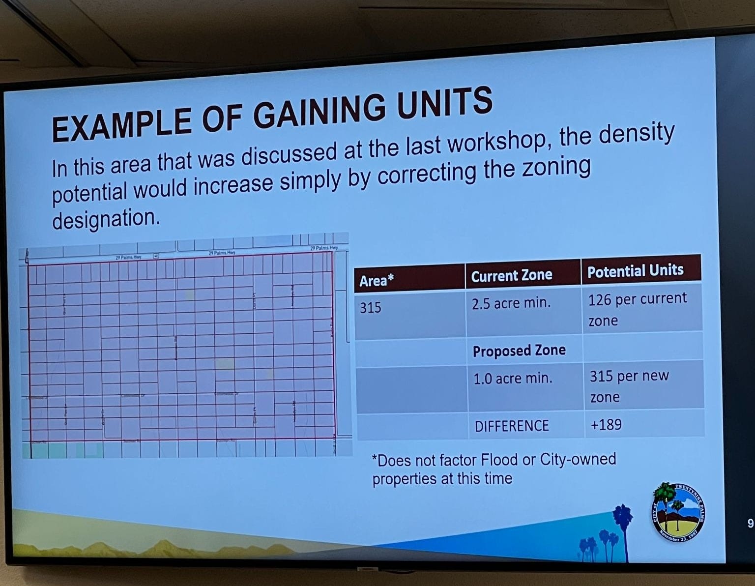
Under current zoning, this region has 2.5 acre minimum allowed density, which equates to 126 potential housing units. Gardner has suggested that changing the allowable density from 2.5 acre minimums to a 1 acre minimum would result in a net-gain of residential housing capacity and reflect what’s actually on the ground in terms of parcel makeup.
In the example provided in the image above, converting this 315 acre space to 1-acre minimum zoning could result in an extra 189 potential housing units.
Gardner presented the RL-2.5 to RL-1 example purely as an illustration of how the gain side of the no-net-loss calculation could work. Addressing the Commission from the public was Carlos Blandon who was the sole commenter from the audience. Blandon pushed back on staff’s framing that the zoning problems inherited by the county during the City’s incorporation were simply an oversight.
Overarching Discussion: “Simple Questions With Profound Impacts”


City staff has posed a series of overarching questions to the Commission throughout these workshops. Some of those questions include:
Should an "Open Space - Conservation Land Use District" be created?
Should a "Utility Land Use District" be created to reflect ownership of the various utilities? Or should their properties be shown changed to the "Public (P) Land Use District"?
Should we have a "One Map" system, whereas the General Plan Land Use Map and the Zoning Map are the same? Or should we have a "Two Map" system, whereas the General Plan shows broad categories, and the Zoning Map gives more detail?
Should the minimum Land Use District size be maintained, or revisited?
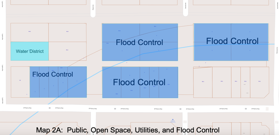
Addressing a section of residentially zoned County Flood Control land between Mariposa Avenue and Lupine Avenue on Map 2A, one of five maps created by City staff so far, Commissioners were in consensus that residentially zoned properties owned by County Flood Control were not ideal for development.
“No one would have ever built there anyway,” said Vice Chair Jim Krushat.
Regarding a parcel on the southern end of Adobe Road acquired by the Twenty-Nine Palms Band of Mission Indians, Commissioner Paahana asked if tribal land counted within the City’s residential housing capacity, which it does not.
Commissioner Cure pushed for taking each overarching question seriously and examine what it means in the bigger picture, seeking clarification from staff on an ongoing question that staff has posed to the Commission in prior sessions: whether the City land use map should change from one single map to a two-map system, and what that would entail.
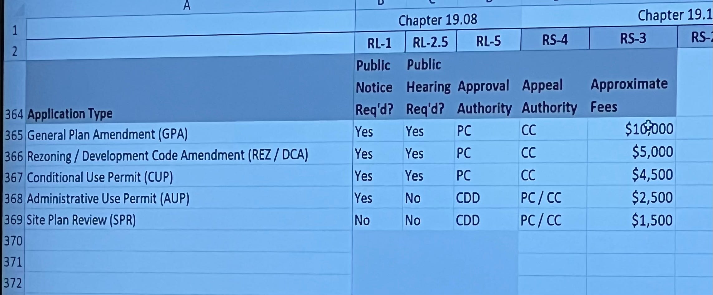
Currently, the city’s Land Use map and zoning map are the same document — so changing a parcel’s density requires amending both simultaneously, a process that starts at roughly $15,000 in application fees. A two-map system would let the General Plan carry broader categories while the zoning map handles finer distinctions, meaning a density change could be accomplished with a simpler, cheaper rezoning alone.
A two-map system would allow certain density changes to be completed via rezoning alone, if that change falls within the General Plan’s permitted range — saving applicants time and money compared to the General Plan Amendment process.
Cure was attuned to the concept of a “drop-down” framing, in which Public land use type would be defined in the Land Use map, then be subdivided into further categories such as Public Parks, or other City owned land. The two-map system would accommodate this, while cutting developer costs.
Gardner suggested that this could make it less costly for a developer to “up-zone,” for instance, with an example of upzoning a parcel from RS-2 (two dwelling units per acre) to RS-4 (four dwelling units per acre). Under the current one-map system, that requires both a rezoning and a General Plan amendment — starting at about $15,000 in application fees. Under a two-map system, it would just be a rezoning at a cost of $5,000.
Gardner emphasized:
They seem like simple questions. They have profound impacts. I guess that’s kind of what I’m getting at.
Chair Walker inquired how often the staff gets requests for such developments. Gardner said it happens but not frequently, implying that once applicants learn the cost of the application process under the current one-map system, they often do not follow through:
Given the restrictions now, given the policies now, once we tell them what the costs are of each of these application types, they, especially on a parcel by parcel basis, don’t follow through because of the cost.
Commissioners agreed that future study sessions would continue to focus on identifying parcels not suitable for development, with approximately 18 more maps anticipated for discussion.
Community Development Director Updates
Director Gardner previewed the Commission’s upcoming schedule:
July 7: A potential public hearing and a workshop.
July 21: Meeting cancellation
August 4 and 18: General plan workshops anticipated.
September 1: General plan workshop.
September 15: Discussion on updates to accessory dwelling units to reflect changes in state law.
The next Planning Commission meeting takes place Tuesday, July 7 at 5 pm. See you there!
Hi, new subscribers! Desert Trumpet understands you might not be interested in all of our coverage. That’s why it’s divided into separate newsletters allowing you to opt out of reporting that’s not important to you. For instance, you may want our Education news but not City Hall 29.
Here’s how to opt out: go to your Substack settings, scroll down to “subscriptions,” and select “Edit” for the Desert Trumpet. Simply uncheck the box next to the newsletters you don’t want to receive in your email inbox. You’ll still be able to access all coverage online if you change your mind.
Thanks to you, Desert Trumpet met our $10,000 paid subscription goal!!!
Not a paid subscriber yet? Did you know that paid subscribers receive discounts on our DT Social events and invites to DT Front Porch, intimate discussions featuring local officials and notable residents?
Upgrade to a $50+ paid subscription for a 10% discount.
Upgrade to $100+ for a 25% discount.
Sustaining subscribers at the $250+ level and above receive complementary tickets.
Leave your thoughts in the comments below. Please note that we do not allow anonymous comments. Please be sure your first and last name is on your profile prior to commenting. Anonymous comments will be deleted.
This coverage is free - please share!
The City has also not been recording its Community Development Director updates, which have been moved to the end of the meeting during the last two sessions.